
A few weeks back I wrote about a trail adventure that my pal Stephanie and I had on the hills above our neighborhood. A wrong turn turned led us on a very confused run. On the plus side we did manage to go eke out 10 miles as we ambled. But we finished the run determined to do a bit of research and try it again.
I don’t want to use the phrase “obsessed” but we were sure as hell going back up to that trail. No question.
So this past Sunday we headed out at 6:00 am (to beat the heat) with our Ragnar Teammate Bill. Team 316!!
Now don’t think just because we brought Bill we were in better directional shape. Bill had never been up on the trails before. So the score before we even started was The Trail 1, Team 316 zero.
Undaunted and armed with 6 strips of cloth (to tie to bushes at specific turns), a map with the route highlighted in yellow and Stephanie’s iPhone we were a go.
We made the climb up to the top of the ridge (the part we already knew) and marked off a few turns with our cloth strips just in case. Check. We consulted the map, turned it around a few times to see which way looked right and make a left turn down the path. Running for about 10 minutes we stopped. Stephanie and I both realizing we had made this wrong turn before. We consulted the now sweaty map and stood looking for guidance by staring down to the houses at Lucas Valley.
Luckily for us (because an answer was NOT coming from the LVHA) a runner came down the hill. He looked very strong and capable and comfortable on these trails. He ran without water and had about 3 percent body fat. He started to pass and we realized he was our chance at help so we waved our arms for him to stop.
Explaining we took a wrong turn and asked if he would kindly help us find the trail to Big Rock. He showed us where we made our mistake on the map (so that was Chicken Ranch) and pointed us back up the hill (damn). He did seem a little surprised that we were attempting an out and back to Big Rock and he offered an alternative trail to the cell towers at the top of the hill. It was shorter but hillier. “A lot of ultra runners train there”.
So back up the hill we ran/walked. At the turn we re-positioned our cloth strip on a log and pulled it into the trail so we could see it on the way back. With our newfound instructions we easily found the trail to Big Rock and also the trail to the cell towers at the top of the hill. A literal fork in the road.
Our running angel had shared that the trail to the tower would take us to the 2nd highest peak in Marin County and was close to 2000 feet high. I figured we were at 1200 already so whats’ another 800 feet. Chuckle. I’m funny that way. High road? Low road? How to decide?
A game of Ro-Sham-Bo, of course. Stephanie and Bill went first and I played the winner. Stephanie won and we went up the high road to the towers. Yeah. The climb was no joke. We went up and around and up higher. (Special thanks to the Hill Family who granted us access to their private property and yes, we did stay on the trail as instructed).
And then we were at the top. Don’t be crazy, it wasn’t like that (insert finger snap) but we were determined to make it up to the top and we all pushed hard to get there. And it was worth it! The view was breathtaking. See those towers at the top of the hills? That’s where we were. 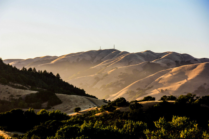
A funny thing happened on the way to the top of the hill. It was a long climb but when we got up there and caught our breath we realized that if we had more time we’d go farther.
There are some gorgeous paths that we could see that would take you further into Novato. Definitely something we’ll do next time.
So we started our descent and made our way back. Now my friends joked about my cloth strips but they did come in handy! Except for the one that was tied to the log. When we came back to that trail the log was gone. Like completely gone. Someone had moved our marker. So rude.
So this trail adventure ended up being, you guessed it 10 miles. Full disclosure, we were slow but I think we all consider this run a victory. The towers were at 1890 feet according to my Garmin. Adding in the ups and downs of the path we had an elevation gain of 2,900 feet and a loss of 3,011 feet.
That explains the quad tightness the next day.
So after this tough run I feel more confident about our race on June 11. I’ll let you know after.
Now go run!
Keli 🙂
